Back متنزه فانواز الوطني Arabic Taman Nasional Vanoise BAN Nacionalni park Vanoise BS Parc Nacional de la Vanoise Catalan Vanoise National Park CEB Národní park Vanoise Czech Parc national de la Vanoise Danish Nationalpark Vanoise German Nacia parko Vanoise Esperanto Parque nacional de la Vanoise Spanish
| Vanoise National Park | |
|---|---|
| Parc national de la Vanoise | |
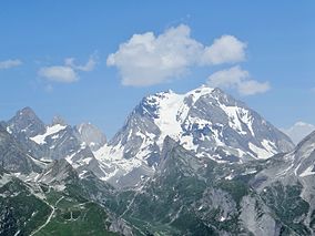
 Grande Casse (3855 m), highest summit of Vanoise | |
| Location | Savoie, France |
| Nearest city | Modane Bourg-Saint-Maurice |
| Coordinates | 45°20′N 6°50′E / 45.333°N 6.833°E |
| Area | 534 km2 (206 sq mi) |
| Established | 6 July 1963 |
| Governing body | Parcs nationaux de France |
Vanoise National Park (French: Parc national de la Vanoise) is a French national park between the Tarentaise and Maurienne valleys in the French Alps, containing the Vanoise massif. It was created in 1963 as the first national park in France.
Vanoise National Park is in the département of Savoie. Small villages like Champagny-le-Haut, Termignon, La Chiserette, Bramans, Sollières-Sardières, Friburge, Pralognan-la-Vanoise and Séez, lie near the park. The park is bordered by several large French ski resorts (Les Trois Vallées, Tignes, Val-d'Isère, Les Arcs, La Plagne).
On the Italian side of the border, the park is continued by Gran Paradiso National Park. Together, these two parks cover over 1250 km2, making the area the largest alpine national park.

